Friday, December 27, 2019

Christmas in Cambodia

We're off on another adventure, but this time with our adult children and the girl's partners in tow. I suspect they decided it might be a good idea to start keeping an eye on their aging, travel addicted parents. Actually, it was our oldest daughter's wish to sponsor a family get together over the holiday season. She is firmly rooted in Switzerland and it has been many years since the rest of us celebrated Christmas with her. Cambodia was her choice destination and although we have been here before, it is new territory for the rest and we are more than happy to return to a country that we enjoyed back in 2012. It took our bodies a few days to get accustomed to the 14 hour time zone difference but we are in full gear now.

We are at end of our first week together and no one has been sent off for a 'time out' yet, although the parents may be the first to be sent to their room when a raucous, late night out presents itself for the youngsters. In Phnom Penh we shared some somber moments at the very descriptive Genocide Museum and the Killing Fields, depicting the ethnic cleansing of over 2 million Cambodians by the brutal regime of the Khmer Rouge party, led by Pol Pot during the 1975-1979 period. We had many more happy times together, sharing stories and having lots of laughs, while sitting at the pool, wandering around the city or spending evenings together with cocktails in hand.

We are now in Siem Reap visiting the ancient temples via tuk tuk and catching other city highlights, including the Angkor National Museum (Khmer history), vibrant Pub Street and the many markets. We were also entertained by an acrobatic show performed by disadvantaged street kids, who attend a nearby arts school that the concerts help fund. Another interesting visit was to the Apopo HeroRAT Centre, where they are using trained African Giant Pouched rats (long life, light weight, easy to transport, incredible sense of smell) to detect landmines left all over the country from multiple wars.

Christmas is not a big celebration in this Buddhist country but we have come across Christmas decorations that are primarily set up to draw in the tourist crowd. No turkeys in sight though. There was one common Christmas theme though.......our kids were out of bed before we were on Christmas morning. However, instead of having a sneak peak at the gifts under the Christmas tree, they all headed out at 5 am for the sunrise at the Angkor Wat temple......we joined them a few hours later!

Tomorrow we will move on to the island of Koh Rong Sanloem, a lovely sand beach resort destination located just off the west coast of Cambodia, where we find or create our own New Year's Eve party.


Our first morning in Phnom Penh. Waiting for our Swiss daughter and her partner to arrive,we went for a short walk around the hotel neighbourhood watching out for ATM's (to get Cambodian riels) and supermarkets for supplies. It didn't take long in the 33C heat to stop for refreshments.

The Central Market in Phnom Penh. The local markets are always interesting to walk through, observing the type of goods for sale and watching locals purchase unrefrigerated meat and fish.

Walking along the Tonle Sap River in Phnom Penh we noticed this well decorated tourist riverboat (among many others) set to take guests on dinner cruises along the river.

Angkor Wat at sunrise. Truth be told, I borrowed this shot from my Swiss daughter since Pocahontas and I were in bed sleeping at the time. We did the sunset picture 8 years ago and knew there would be thousands there attempting to get the perfect sunrise shot, so we joined up with them a few hours later.

The lovely Bayon temple within the Angkor Thom complex. The king's face was carved into the stone facade of all the towers within the temple.  The Angkor Thom complex was more than 10 square miles, once housing over 1 million inhabitants.......at the same time (~1200) that London, England was home to 50,000 people.

Stone wall carvings in a narrow hallway of the Terrace of the Leper King within Angkor Thom. These late 12th century carvings were well preserved due to a location well protected from the elements (and a ways away from the tourist masses).

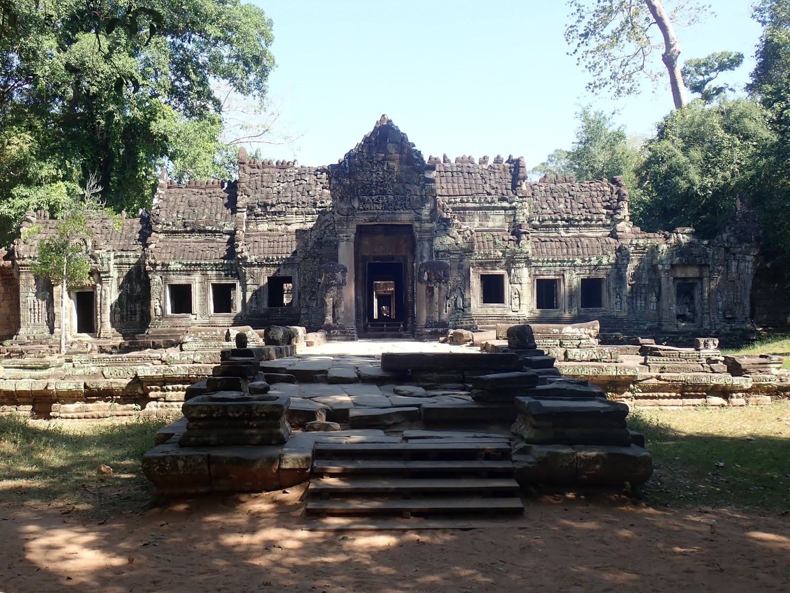
The Preah Khan Temple. The entrance way ahead led to a long hallway that went for more than 200 metres with access to may rooms on each side. The temple was the home of the king (Jayavarman VII) while the Bayon Temple was being built.

Back in Siem Reap we went to a show under the Big Tent, sponsored by the Phare group who established a nearby school for disadvantaged children. The school features the arts and showcases the students in nightly, near capacity shows that help to support the schools. Many of the acrobatics performed rivaled Cirque de Soleil performances, telling a story at the same time.

The fascinating Apopo centre where we learned about the use of African Giant Pauchon rats from Tanzania that are trained to detect landmines. They are much more efficient and safer than metal detectors because they smell the explosive material rather than just metal objects. We were told that the HeroRATS can cover territory the size of a tennis court in 30 minutes while it would take 4 days to do the same with a metal detector.....and not a single rat has perished in the searches which started in Laos back in 2010.

Thursday, July 11, 2019

Time to Start Planning our Next Trip

The drive from Grande Prairie to Jasper was another scenic journey, reminding us once again that you do not need to leave Canada to experience beautiful scenery......we have it in abundance throughout our 10 Provinces and 3 Territories, which we have been fortunate to visit. The reward of the drive was arriving in the Jasper area, surrounded by mountains, lakes and rivers. We were unable to secure a campground site in the National Park due to the holiday w/e crowds, so we had to settle for an RV Park outside the park boundary. It required a 40 minute drive each day back into Jasper but we never tired of the highway views and the different species of wildlife that came out to greet us on each trip (bears, moose, sheep, goats).

On our first day we drove to the colourful Patricia and Pyramid Lakes and the magnificent Maligne Canyon where we walked along the trails observing the river blasting it's way through the narrow canyon. We also discovered the Folding Mountain Brewery which was crowded with locals and visitors enjoying their craft beers and tasty food. Canada Day followed, so we headed into town early to find a strategic parking spot for the day, in order to experience the many events going on to celebrate our 152nd birthday. The day started with a pancake breakfast in the central park, followed by a flag raising ceremony, a parade through the town, a historical town walk and a Party in the Park with live entertainment. Unfortunately, it rained on and off during the day, cancelling the Royal Canadian Air Force fly-by and diminishing the crowds for the park party. The fireworks show had previously been cancelled due to the fire ban in the area, only to have it rain for several days leading up to the party. When the rain became more persistent later in the day we decided to leave the town site and return to the craft brewery near our RV Park for some more local brews and dinner. Our final day was filled with sunshine, which worked out perfectly for us since we had made an advance booking for a round of golf at the Jasper Park Lodge Golf Course, a jewel set in the heart of the Canadian Rockies and one of Canada's top ranked courses. It was a lovely day and we didn't mind that our scores were a little higher than we hoped for.

We finished our trip with a visit to my sister's home in Lac Le Jeune, where we had a heartfelt family re-union, lasting 5 days. Lots of wonderful memories shared, small tasks completed and games played. We are now back home, exactly 7 weeks after starting out on this trip, which completes our travels to all 50 U.S. States and our final Territory. Life is good.....everywhere.

The bridge across Pyramid Lake to Pyramid Island. The lake was 6 km's north of Jasper and popular with bike enthusiasts who got their workout on the way up and only had to use their brakes on the way back to town. There was a nice trail circling the island with gorgeous views everywhere.

Maligne Canyon which is a lot deeper than this picture displays. The rushing water continues to carve it's way deeper into the canyon and there were spots where we could no longer see the river below in the narrow canyon.

Mountain Goats on a cliff beside the highway. A bit further down the road we found some more goats patrolling the highway, walking right down the middle of the road on the centre line, causing traffic in both directions to come to a halt until they were finished observing us.

Enjoying some excellent craft beers at the Folding Mountain Brewery, outside the Jasper Park gates. They had 12 different brews to select from and their tasting tray marked the choices each individual made.

Mini-Mounties following the real ones at the Flag Raising Ceremony on the Visitor Centre front lawn. At the end of the ceremony, birthday cake was served to everyone.

The Lumberjack float at the Canada Day Parade, which included a flag covered bear. Almost all the floats had people tossing candies to the crowd......I had to control my competitive spirit to not outrace the youngsters to the prize.

The St. Mary and St. George Anglican Church which we had special access to during our historic downtown walk in Jasper. The church had some 1930's stained glass windows on one side and more modern versions (and equally brilliant) on the other side which replaced the original ones damaged at the turn on of the century when a tree fell on that side of the church and caused significant damage.

Mildred Lake, on our way to the Jasper Park Lodge which was on the opposite side of the lake.

Showing off my form at the Jasper Park Lodge Golf Course.

A panoramic shot of Little Hell's Gate which we discovered on our drive from Jasper along the scenic #5 highway to Kamloops. The deadly whirlpools at the bend on the left side required a 6 km portage for the early settlers and gold rush miners heading up river.

A family Marbles game. Our parent's taught us card games when we were young and the tradition has followed in each of our families.

The beginning of a campfire that lasted into the early morning hours, with neighbours and friends joining in on the celebration. Later on after burning close to a face cord of wood, several wooden pallets were added to the fire, resulting in 7-8 foot high flames.

Saturday, June 29, 2019

A Forest Unlike Any Other

Heading back into the Yukon from our short stay in Skagway, Alaska, we made our way to Watson Lake in the south-east corner of the Territory. The Alaska Highway goes right through the centre of the town and to one of our pre-trip destinations, the Signpost Forest. The 'forest' was started back in 1942 when a homesick U.S. Army soldier, working on the construction of the Alaska Highway, put up a sign indicating the direction and distance to his hometown. Since then visitors have been adding their own signs in the same spot, resulting in an expanding area that has since become known as the Signpost Forest. It now hosts 90,000 signs, with several thousand more being added every year, with the town erecting new posts all the time to accommodate the growth. I managed to find an old barrel nearby to assist me in attaching the sign we brought with us in a prominent spot higher up on a post. Good luck trying to find it in the forest though!

After a night in Watson Lake we drove into northern B.C. to the popular Liard Hot Springs Provincial Park. The campground was 'full' but we found a nearby site, allowing us to spend some time in the park at the lovely hot springs, which were in a natural river. Several of us attempted to get close to the underground source but the increased heat drove us further back where most people still found it very hot. We slept well that night. Following an overnight stay at another provincial park, near Fort Nelson (Charlie Lake PP), we will able to observe an interesting new dam being built on the very wide Peace River. It was in the early stages but signboards displayed all the phases of the project, with telescopes set up to observe the progress and the large trailer village set up to house the 1,600 workers.

Dawson Creek was our next stop, the official start of the Alaska Highway. The Alaska Highway House had an excellent museum and film, describing the construction of the highway in 1942, and the challenges faced along the way (Canadian Rockies passage, thick forests and abundant rivers, and -40C temperatures). The need for the U.S. to secure an inland route to protect Alaska from potential Japanese attacks at the outset of WWII drove the urgency and the task was completed in an amazing 8 months. Almost all of the highway's 2,237 km's resides in Canada (B.C. and Yukon) but the U.S. agreed to provide the army staffing and the necessary supplies in return for the land access. It was a good deal for Canada, allowing for a future transportation route through a challenging part of our country.

We are now in Grande Prairie, a return trip for Pocahontas from 40 years ago when there were no paved roads in the city. The population has doubled in the past 20 years thanks to the oil and gas industry. They also have an impressive, award winning Dinosaur Museum showcasing the numerous deposits of bones found in the area, but the museum is having trouble making ends meet due to it's remote location.

We will drive to Jasper in the morning where we will partake in a full day's worth of Canada Day celebrations going on there.

The Signpost Forest in Watson Lake, Yukon. A friend of mine put up a sign here several years ago but I had no luck finding it amongst the 90,000 signs already posted. Now our sign is embedded in the 'forest' for others to seek out. It was entertaining to walk around and observe the various signs from around the world.

While driving between Watson Lake and Fort Nelson we were warned to watch out for wild Bison along the roadway. This beast would incur significant damage to any vehicle that got in it's way. I have a humourous video of another bison wallowing in the dirt which is apparently either an attempt to ward off insects, or in mating season to advertise their physical condition to other males. He convinced me to move on.

The Liard River Hot Springs in the provincial park by the same name, the second largest natural hot springs in Canada. The park made it easy to enter the river with the decking and stairs. The left side of the picture is close to underground source so most people migrated to the right side which was a bit cooler but still hot tub hot.

Rock Sheep also made a deliberate display of their ownership along this section of the Alaska Highway. This mom had a lamb following behind, also right down the centre of the highway.....a training session I suppose..... forcing vehicles going in both directions to pull over to the side of the road while they sauntered by.

The picturesque Muncho Lake which we passed by on our way to Fort Nelson. With the wildlife, mountains and rivers / lakes, this was one of the scenic stretches along the Alaska Highway.

We made a quick stop into the Toad River Lodge after reading in our Milepost guide that they had a large collection of hats. Passers-by keep adding to the collection which now numbers 11,204 hats. The up-to-date count is written on a chalkboard and updated every time a customer adds a hat to the assemblage.

The Kiskatinaw Bridge, the only original Alaska Highway timber bridge still in use today. An asterisk must be attached though, since this one exists on the old highway.....requiring a short loop diversion from the current route. We doubt it will be in use much longer since it already has weight restrictions for vehicles. It was still an impressive accomplishment and sight.

The beginning of the Alaska Highway in Dawson Creek, B.C. The Visitor Centre, attached to the grain elevator, issued Mile 0 certificates, but for us it was Km 2,237 since we drove the Alaska Highway in reverse order, from Delta Junction, Alaska to Dawson Creek.

The back of the Alaska Highway House museum in Dawson Creek was painted to make it look like it would have been in the 1940's. The museum inside did a wonderful job sharing the construction and history of the highway.

Saturday, June 22, 2019

Land of the Midnight Sun

As we continue to roll through Alaska and the Yukon, we are gifted with very long days, a blessing for travellers. For the past 10 days, leading up to today's Summer Solstice, we still had enough light outside to play baseball until midnight....if we had a bat and a baseball. And it never really got dark so by 3 am in the morning, the games could be back on again. At our furthest points north, in Fairbanks and Dawson City, the days we even longer. The downside to all of this however is that it is the worst time of the year to see the Northern Lights so we have had to settle for a few museum films and art work displaying the magnificent sky views that occur during the winter season.

When we last left you, we were in Fairbanks, Alaska, a city we enjoyed even more than Anchorage. A definite highlight was the U of A Fairbanks Museum of the North, filled with historical, ecological and native heritage information, presented in an easy to follow system. I suppose that is what learning institutes are intended to do! From there we made short stops at the North Pole (Alaska version), Delta Junction (end point of the Alaska Highway) before eventually landing in Dawson City, Yukon. The city built it's fame on the late 1890's gold rush and a self-guided walking tour of the downtown area showcased many of the restored buildings. We also took in an amusing show depicting several of the gold rush characters that I somewhat reluctantly made a cameo appearance in, much to the delight of Pocahontas. Then we made our way to Whitehorse, which like most capitol cities seemed to have more money spent making the city beautiful than in other populated areas of the province.The downtown 5 km Millennium Loop Trail along the mighty Yukon River was a pleasure to walk and seemed popular with the locals as well. Miles Canyon, just outside the city was another treat, with the River rushing through the narrow canyon below us and nice trails that continued 10 km's back into the city.

We are now back in Alaska, in the small and interesting, but touristy town of Skagway, where we have been for the past 3 days. Every day two to four large cruise ships show up in the harbour next to our campground, and unleash their passengers on the town between 8 am and 7 pm. The shopkeepers receive a monthly schedule indicating which ships are arriving each day along with the total number of passengers so that they staff up accordingly. That number ranges from 5,000 (w/e's) to 11,000 (weekdays), so this town of 1100, mostly comprised of people in the service industry, comes alive during the cruise ship season. In 2019 there were 1.9 million visitors to Skagway and almost 1.8 million of them were on cruise ships. They likely get this information from the Border Patrol staff since the only road to Skagway comes from a short stretch of British Columbia, which somehow gained ownership of  the land from the Yukon, just like the U.S. did to Canada along the west coast. Check out a map and you too will wonder how this came about. In any event, Skagway has been a delight to visit. The harbour access brought the Klondike gold rush seekers here by ship and they then trekked through the mountainous and challenging Chilkoot and White Pass trails to reach lakes and rivers that could carry them on to Dawson City and other gold fields. There is plenty of history to tell and we really enjoyed our walking tours, a Soapy Smith (quite a character) show, the Gold Rush Cemetery, along with several short hikes (Reid Falls, Smugglers Cove - geocache find!). A special highlight was a trip on the narrow gauge, cliff side hanging, Yukon Railway to White Pass Summit and back with a narrator pointing out historical landmarks. Being close to the ocean for the last time on this trip, we took advantage of fresh seafood, enjoying meals of Alaskan King Crab, Halibut and Sockeye Salmon.

Tomorrow we will head back to the Yukon, this time to Watson Lake. We are looking forward to our return trip north along the incredibly scenic #2 Highway towards Whitehorse where we will rejoin the Alaska Highway.

The entertaining Museum of the North, stationed on the grounds of the University of Alaska Fairbanks campus. We got excited about visiting the museum as soon as we saw it from the outside.

This picture (no flash) was taken from our camper van at 1:30 am, the midpoint on that day between sunset and sunrise. We have dark curtains inside so the night light was blocked.......and to be clear, we were not up partying at that time, one of us had to get up to use our tiny bathroom!

The small village of Chicken, Alaska, which we stopped into just before crossing the border into the Yukon. Their population ranges from 7 (winter) to 50 (summer) but this crowd attended an annual music festival and we sadly arrived the morning after it finished. We observed a lot of people who looked like they had a very, very good time the evening before. The directional sign listed places around the world with poultry related names. The original village was named Ptarmigan, reflecting the vast numbers in the area but the villagers had trouble pronouncing and spelling the word so they made the change to Chicken.

The famous Downtown Hotel in Dawson City (dirt streets only, embracing their past) where we stopped into in order to watch the final round of the U.S. Open golf tournament. It was also the home of the Sourtoe Cocktail with almost 90,000 people receiving a certificate for drinking the cocktail. Besides lots of alcohol, it includes a a severed big toe (not pretty) which is supposed to touch your lips but not be swallowed. It used to be a $500 fine for swallowing the toe but after a patron decided it would be a story telling move to do so, the fine was raised to $2500. Almost 50 years later, they are now on their 15th toe! The cocktail is only served in the evenings, well after we were leaving, so I don't have a certificate.......but i have a friend who does!

A view of Dawson City and the Yukon River from the Midnight Dome. We decided to have a van lunch up there, gazing at the view around us all the time.

The Best Klondiker show in Dawson City, Yukon, where I was randomly selected to be a participant. I later found myself explaining why a non-hunter or police officer was holding a shotgun in his hands.

The out-of-service SS Klondiker in Whitehorse, beside the Yukon River. We saw several of these sternwheelers while travelling along the Yukon River. They were used to carry both passengers and supplies up to Dawson City

The  picturesque Emerald Lake (Yukon) beside the #2 Highway on the way to Skagway from Whitehorse. The colours are a result of the white sediment (marl) at the bottom of the lake.

A bit further south along #2 we stopped into the small town of Carcross which is proud of it's First Nations history. Various shops displayed lovely native art and products. We made several purchases to bring back home.

The main street of Skagway, Alaska. This picture was taken later in the day when most of the passengers had returned to their ships prior to departure.

Our train trip to White Pass Junction. The narrow gauge rail line was built in the early 1900's.......and hopefully reinforced since then...........to get people and supplies to the Canadian Klondike, avoiding the many deaths (people and horses) that suffered from the mountainous trail journey.

The Days of 98 show in Skagway. The colourful and notorious con man, "Soapy" Smith is in the background behind the can-can ladies (of the night). 

Friday, June 14, 2019

Almost Daily Sightings of Moose and Bears in Alaska

We arrived today in Fairbanks, Alaska, the furthest point north in our driving trip. The temperatures here are summer-like, mid-20's celsius, even though it is not officially summer yet. The days are long, with the sunset after midnight, and sunrise at 3 am......so it is difficult to know when to go to bed and get up!

When we last left you we were back on the ferry headed to Whittier, Alaska from Juneau. It was a little less exciting than our first ferry trip (with land on both sides) since the ship left the inland passage heading NW into the Pacific towards the Kenai Peninsula. There were still plenty of whale sightings along the way and we arrived on the mainland two days later. After waiting 20 minutes to enter the one-way, 4 km. long Whittier Tunnel (vehicle and train traffic access flips every half hour) we had a quick stop at the receding Portage Glacier before driving south to the lovely seaside town of Seward. We found an RV site close to the water, exploring the impressive Exit Glacier (with signs showing the recession of the glacier since the 1800's, not seemingly much worse than recently) on the first day and taking a National Park Ranger led boat tour on the second, increasing our (short term!) knowledge of the surrounding area while getting the opportunity to view Orca's for the first time on this trip along with plenty of other sea life (including humpbacks and sea otters).

From Seaward we drove along a very scenic highway north to Anchorage. It was a bit early for the King Salmon full run but their spawning journey had definitely started as we spotted many fisherman standing in Ship Creek hoping to catch the early arrivals. We visited a large hatchery further up the creek where the surviving salmon laid their eggs and they were helped along until they became fingerlings and even larger before re-releasing them back into the creek to head back to the ocean. We also took advantage of the lovely weather to golf at the 2015 Alaska Golf Course of the Year, Moose Run. Unfortunately, since then they seem to have sat on their laurels with regards to maintenance and we found it in sad shape. The highlight of the day was being held up at the par 3 3rd green when we saw an enormous bull moose, with a huge rack, on the green and walking around very slowly. When he finally decided to leave 5 minutes later we watched as the terrified group in front of us reclaimed their golf clubs and balls, while a marshal tamped down the foot marks with a special instrument that let us know this happened often. We had also been warned of a bear on the 11th hole so it reminded us of golfing in Kananaskis back home.

From Anchorage we headed further north to the magnificent Denali National Park, with a brief stop along the way in the unique town of Talkeetna, where Mt. Denali (over 20,000 feet) trekkers assemble for permits and certification before the difficult climb to conquer North America's highest mountain. The locals, liking their town the way it was, successfully lobbied the government to prevent the northbound highway from getting close to their village. We spent two cold and full days exploring Denali NP, using NP tours and buses to get almost 100 km's into the park where vehicle traffic is wisely prohibited. The bus driver-guides were excellent at spotting wildlife along the way but also encouraged the passengers to shout out "STOP" whenever they noticed something moving so the bus would stop very often allowing everyone to get photographs. Our Ranger guide on the first bus had an impressive zoom camera hooked up to the bus monitor system so when she locked into the wildlife we observed it was displayed on the many bus screens, even closer than our cameras or binoculars could emulate, so many of the passengers ended up taking photos of the video screens! We saw plenty of bears (mostly grizzly's), moose, caribou, dall sheep, fox (red and silver) and even a golden eagle, along with plenty more. We managed to see the elusive peak of Mt. Denali (30% visibility daily, formerly Mt. McKinley, but recently changed to the Athabaskan native name of the "big one"). Would-be climbers have a 60% success rate due to both altitude sickness and -40C temperatures, even during the summer climbing season. For a brief moment I was sure I could beat those odds, having climbed Kili 5 yeas ago, but when I heard about the average 3 week climbing schedule and the frigid temperatures, not to mention I would need a lot more more equipment than I brought, and a drive back to Talkeetna to get my permit, I sacrificed another milestone rather than ask my bride to hang around for a month wondering if she would have to drive all the way back home on her own.

On our way to Fairbanks we dropped into the small town Nenana which hosts the annual Ice Classic Contest. They place a tripod in the middle of the very wide Nenana River once it freezes and then run a state-wide lottery to guess when the ice will break in the spring. Tickets are $2.50 and participants need to guess the day, hour, and minute when the ice will break causing the tripod to drop, all of which is monitored by a camera and clock. This year's winner took home $311,000 for projecting the exact time.

Fairbanks, from our first afternoon, seems more appealing than Anchorage. More details to follow!

After driving through the Whittier Tunnel, where a train was waiting to go in the opposite direction through the tunnel, we wandered over to Portage Lake and took this photo. The Portage Glacier has now receded behind the darker mountain on the right so we passed on a boat ride out to the base, knowing that we had plenty of more visible glaciers ahead of us on this trip.

The Exit Glacier in Kenai National Park. We hiked further up the path to catch a glimpse of the bottom end of the glacier but the overall view was not as good. The NP had places along the road and hike indicating where the glacier was in earlier years which was quite remarkable.

A morning stroll along the seaside path beside our waterfront RV park.

The Seward harbour area which is frequently visited by cruise ships.

While in Anchorage we visited the Ship Creek Hatchery. This room contained salmon fingerlings, with thousands in each tank. They also had rooms for Arctic Char and Rainbow Trout, releasing all of the young fish into Ship Creek when they could cope for themselves (without their mothers who die naturally after laying their eggs in the same place they were born).

The main street of Talkeetna, an old mining town established in the late 1800's. The small unique town was formerly led by Mayer Stubbs, a cat, who passed away two years ago, after 20 years on the job.

While driving our van into Denali National Park we came across this moose very close to the road.

Mike the Moose, attempting to hold a 25 pound half rack on my head. 

A grizzly sow and her cub on the bus monitor. The pair where approximately 300 metres away from the bus (further away than others we saw), but our driver-guide was able to zoom in on them for all the passengers to see.

A typical view within Denali NP. The 6 million acre park was carved by glaciers that melted over time to create wide rivers that are now a fraction of what they used to be, It did however provide a lot more space for the abundant wildlife that now populates the NP.